High-quality localized geological data is essential for critical decision-making in underground mining. Traditional face mapping often results in inconsistent geological interpretations and incomplete data that isn’t digitally characterized or attributed, making it difficult to use for timely operational decisions.
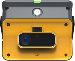
GroundedAI (formerly RockMass) addresses this challenge by equipping teams with a streamlined solution for 3D data capture, annotation, storage, and data conversion. This helps improve the flow of geological information into operational decision-making and reporting tools.
Industry Challenge
Mining operations often struggle with ambiguous geological data, which hinders precise local modeling and slows down decision-making.
- Geological features are commonly mapped manually, without a standardized approach, leading to interpretation variability between geologists
- Poor or generalized georeferencing practices limit the ability to integrate data into block models or geological databases
- In fast-paced environments, delays caused by unclear or inconsistent data can impact both safety and ore recovery
- Mapping outputs are typically image-based and don’t allow users to extract, share, or integrate attributes into centralized geological models
- There’s a lack of tools to efficiently capture, map, aggregate, and visualize localized geological data while preserving spatial accuracy and compatibility with standard post-processing tools
GroundedAI Approach
GroundedAI simplifies complex point clouds and enables user-driven mapping of localized geological features such as faults, shear zones, and veins. These features are displayed in intuitive, georeferenced visual formats that are ready for integration and analysis.
Note: Mapping is currently user-driven, but automation is part of our future development roadmap. Get Early Access to our community.
Workflow Example
- Capture 3D data using flexible methods (LiDAR, drone, handheld scanners)
- Conduct user-driven mapping of geological features
- Apply precise georeferencing for spatial accuracy
- Generate easy-to-understand outputs to support fast, informed local decision-making
Key Benefits
- Improved localized geological understanding
- More precise geological modeling and interpretation
- Faster decision-making in dynamic mining environments
- Standardized capture and organization of geological data
- Integration of geological, geotechnical, and sampling data into a unified structure
- Enables reporting, analysis, and modeling workflows
- Supports planning and resource estimation with timely insights
- Unlocks advanced analysis—correlate ore grades with structural and alteration features for deeper understanding
- High-quality, structured data serves as a strong foundation for predictive modeling and future automation
Schedule a consultation with GroundedAI to unlock the value of localized geological insights in your operation.


