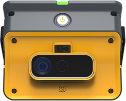
Accurate as-built ground support records are essential for managing underground excavation performance, enabling back-analysis, compliance tracking, and future design refinement. Traditionally, documenting support installations has been a manual and time-consuming process, often prone to gaps and inconsistencies.
With RockMass Eon, geotechnical teams can now capture high-resolution, georeferenced support records systematically and efficiently, delivering new levels of transparency and accuracy to underground ground support documentation.
Many underground mines lack comprehensive, up-to-date records of installed ground support. Manual mapping and field logs may miss support elements, misidentify installation locations, or become outdated as conditions evolve. This limits engineers’ ability to:
The result is reactive and fragmented ground support management, leading to missed opportunities for optimization and risk reduction.
RockMass Eon offers a rapid, digital solution to generate reliable as-built records. Using LiDAR scanning combined with digital support identification, Eon captures detailed 3D point clouds of excavation surfaces and enables recognition of installed support elements, including bolts, mesh, shotcrete, and cable anchors.
The data is accurately georeferenced and exportable, making it easy to visualize, share, and integrate into geotechnical workflows.

Make the underground visible

Stay ahead with our monthly bulletin—get case studies, product updates, and event news.
