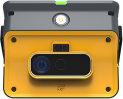
Stope design is a core element of underground mine planning. It requires balancing ore recovery, ground stability, and operational efficiency. Geotechnical engineers must integrate complex datasets and structural interpretations to make informed decisions, often under time pressure and with limited data.
RockMass Eon supports this process by delivering high-resolution structural data directly from the field to the design environment. It empowers geotechnical teams to produce safer, more optimized stope designs with accurate, real-time information.
Traditional stope design workflows often rely on incomplete and inconsistent structural datasets derived from core logging or manual face mapping. These methods are time-consuming and may fail to capture the variability of in situ rock mass conditions. This can lead to designs that are either too conservative, increasing cost, or too risky, compromising safety.
Without comprehensive structural inputs, engineers face challenges such as:
RockMass Eon automates and streamlines the collection of structural data using LiDAR and advanced algorithms. The system captures key parameters such as in situ discontinuity orientations, spacing, and trace lengths in active headings and stopes.
The result is a spatially rich structural dataset that integrates directly into:
This improves both the accuracy and speed of stope design development.

Make the underground visible

Stay ahead with our monthly bulletin—get case studies, product updates, and event news.
