RockMass is evolving. Welcome to GroundedAI — the platform powering the future of underground mapping and reporting.

July 10, 2025

Blogs

From Complex Point Clouds to Clear Structural Mapping: Enhancing Mine Safety

Blog Image

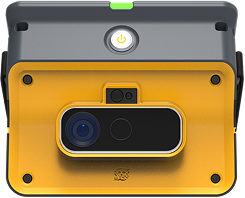
Safety in underground mining depends on timely and accurate structural data that helps identify hazards before they impact operations. While point cloud data offers rich detail, it can be difficult to interpret both visually and computationally. This complexity often results in incomplete assessments, missed hazards, or underutilized datasets.

GroundedAI (formerly RockMass) simplifies structural mapping by delivering actionable insights directly from 3D scans. Our approach helps teams extract and interpret the most critical geological features, supporting proactive ground control and operational safety.

Industry Challenge

Structural instability is one of the primary causes of underground mining incidents globally. Extracting key geological structures from complex datasets remains a major challenge for effective risk management.

  • Traditional structural mapping methods are time-consuming and rely heavily on individual interpretation
  • Results often vary between geotechnical engineers
  • Structural data is frequently siloed and difficult to integrate into centralized systems

These issues make it harder for teams to identify hazards, delaying key decisions and increasing risk exposure.

GroundedAI Approach

GroundedAI converts raw point cloud data into clear, simplified structural maps that highlight joint orientations and geological hazards. Using tools like stereonets and structural disks, we present the data in a visual format that is easy to interpret and act on.

Our solution is focused on removing complexity from point cloud interpretation and delivering the most important structural insights quickly and clearly.

Our process includes:

  • Capturing structural data in active headings
  • Applying precise georeferencing
  • Mapping critical structural features
  • Delivering risk-focused reports
  • Preparing datasets for downstream analysis in industry-standard geotechnical software

Workflow Example

  • Capture high-resolution 3D structural data underground
  • Georeference data precisely within the mine grid
  • Map key geological structures with a focus on those critical to stability and risk
  • Generate intuitive structural reports for geotechnical review
  • Export datasets for integration into software like DIPS, Unwedge, RS2, or Vulcan

Key Benefits

  • Improved hazard identification through enhanced visibility of structural features
  • Lower risk of structural failures by enabling timely interventions
  • Consistent, intuitive presentation of complex structural data
  • Faster structural assessments that support operational safety and decision-making

Call to Action

Strengthen your structural analysis workflows with GroundedAI. Contact us to learn how we help improve safety and data clarity in underground operations.

RockMass

Eon

footer-cta-card-1

GroundedAI

Make the underground visible

Newsletter

Stay ahead with our monthly bulletin—get case studies, product updates, and event news.

Thank you! Your submission has been received!
Oops! Something went wrong while submitting the form.
footer-cta-card-3